Not rendering ocean tiles at zoom 10 or higher #308
Comments
|
my guess this is related to the "Overzooming support" - #168 |
|
I noticed bug 168 but it has has no response and is over a year old. I would not consider this to be 'overzooming', I also do not expect there to be more detail when zoomed. I expect a blue tile. In the users eyes this behaviour is classified as 'tiles not rendering'. |
You can check yourself - the data ( ocean vector tiles ) exists - in the .mbtiles file?
|
|
Not simple for me. Can you link me to some info on how to do this? I have no issues running a query, it's constructing the query I am unclear on. |
it is very complex .. multiple layers of understandings .. As I see - The better terminology : "maskLevel" or "fillzoom" - support. from the draft tilejson-spec (next) v3.0.0 definition : https://github.com/mapbox/tilejson-spec/pull/36/files see more: https://github.com/mapbox/tilelive-vector implementation ( maskLevel , fillzoom ) |
|
Thanks for the background. As I am not a developer by trade much of it is over my head. It appears as if I cannot implement a fix for this on my current version, is that right? What is the target release date for 3.0.0? |
No. :) |
|
Anyone know if there are updates on this? My tiles are only available up to zoom level 16. |
|
Same happens to me, for a specifica bridge in Brazil. Only renders it at 13 zoom level. |
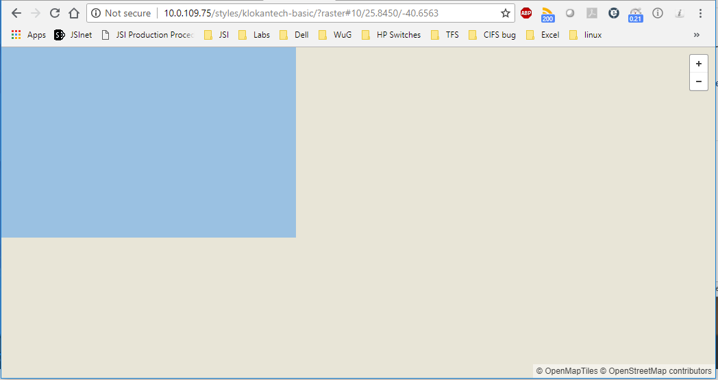
When zooming into a map over an area that is ocean the tiles are white at zoom level 10 and above. This happens for both raster and vector tiles. This behaviour is present in several deployed systems. Issue exists in both osm-bright style and klokantech-basic.
Expected behaviour would be for the tiles to display as blue, the same as they do at lower zoom levels.
Tileserver-gl version: 2.3.1 docker container
Map version: osm-2018-06-14-v3.8
Server OS: CentOS 7.5 build 1804
Test by checking the tileserver URL "/styles/osm-bright/?raster#10/26.3857/-40.4290".
Screenshots:

The text was updated successfully, but these errors were encountered: